
Regional Intelligent Transportation Systems (ITS) Architecture
The Wichita Area Metropolitan Planning Organization's (WAMPO's) Regional Intelligent Transportation Systems (ITS) Architecture serves as a framework for the planning, deployment, integration, and operation of technology-driven solutions within the regional transportation network.
Regional ITS Architecture 2025 Update
In Fall 2025, WAMPO completed an update to the regional Intelligent Transportation Systems (ITS) architecture, as required by federal guidelines to occur every five years. The 2025 update builds on the last comprehensive update which was completed in 2006. It includes an inventory of existing ITS infrastructure and outlines future deployment strategies based on extensive stakeholder input. These materials were offered for review by federal planning partners and released for a public comment period before being brought to the WAMPO Transportation Policy Body (TPB). The WAMPO TPB approved the updated Regional ITS Architecture on November 18, 2025.
Regional ITS Architecture Documents
Introduction to the ITS Architecture documentation and summary of the 2025 ITS update outcomes.
A companion to the ITS Architecture, this document covers some of the most current and evolving elements. Highlights include individualized summaries of stakeholder priorities and contextual insights from the 2025 update, which culminate in a time-phased project table that reflects those priorities.
The ITS Architecture Report outlines the purpose, geographic scope, and architecture components in greater detail. It also serves as a basic guide to understanding how the architecture is documented using the RAD-IT software. RAD-IT is a widely used, federally supported tool developed to assist in regional ITS architecture development.
The above links to a set of interconnected webpages, which presents the WAMPO regional ITS architecture in a navigable, web-based format for easy reference and review. These pages were generated by RAD-IT. A widely used, federally supported tool developed to assist in regional ITS architecture development.
Regional ITS Architecture Maintenance Plan
The regional ITS architecture is a living document that requires updates as priorities shift and technologies evolve. A maintenance plan was developed to guide ongoing updates and ensure continued utility.
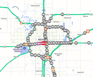
WICHway ITS
While the ITS architecture spans multiple jurisdictions, technologies, and deployments, one of the most significant and visible is the WICHway system, which covers much of the highway network in the Wichita area. The WICHway network includes 89 closed-circuit cameras, 79 traffic sensors, and 33 dynamic message signs. A Traffic Management Center operates 24/7 to monitor traffic conditions, post messages, and update the website (www.WICHway.org) to help drivers navigate incidents, severe weather, construction, maintenance, and special events.
WICHway is owned and operated by the Kansas Department of Transportation in collaboration with partners including Sedgwick County, the City of Wichita, the City of Derby, the Kansas Highway Patrol, the Kansas Turnpike Authority, the Wichita Area Metropolitan Planning Organization (WAMPO), and the Federal Highway Administration.
KanDrive.Gov
Stay informed with real-time traffic updates from the WICHway ITS system, available at https://kandrive.gov. Access live video feeds, view current incidents and road closures, and explore other important travel information. See below for examples of what you can find on KanDrive.
Location of WICHway Cameras
Example of Live Video Feed at K-96 & Hillside

Location of Dynamic Messaging Signs
